


 Dave Burton@ncdave4life
Dave BurtonJun 10, 2024
9 tweets
1/9. @NASA Climate is not one of the divisions & departments of NASA that do science. It's the "JPL Earth Science Communications Team" in Pasadena, which is comprised of "communicators," not scientists.
sealevel.info/learnmore.html
NASAClimate is a frequent source of misinformation and outright political propaganda.


NASA Climate@NASAClimate
Jun 08 24
View on Twitter
Sea levels around the world are rising as a result of human-caused global warming. Overall, global sea levels have risen about 10 centimeters from 1993 to 2023. #WorldOceansDay
go.nasa.gov/3VuV88X
2/9. Many other parts of NASA still employ real scientists, who do excellent work.
Here's a NASA video about some of that work.
youtube.com/watch?v=zOwHT8
CO2 emissions are very beneficial for natural ecosystems, and NASA satellites measure the resulting "greening" of the Earth.
3/9. Do you worry about the Antarctic Ice Sheet melting? This excellent NASA study should put your fears to rest.
cambridge.org/core/journals/
x.com/ncdave4life/st
Note: Antarctic temperatures average below −40°, so a few degrees of warming obviously cannot melt it.

Dave Burton@ncdave4life
Dave BurtonApr 12 23
View on Twitter
Antarctic ice mass fluxes are in near perfect balance. The best & most comprehensive study to date of Antarctica ice mass fluxes is this one, from NASA:
cambridge.org/core/journals/
The ice mass trend is −12 ±64 Gt/yr. That's ≅ zero. (12 Gt/yr = 0.1 inch of sea-level per century.)

4/9. Here are two photos of the Moana Surfrider Hotel on Waikiki Beach, in Honolulu, one taken in 1925 and the other recently. They illustrate how negligible the sea-level trend is.
sealevel.info/moana_hotel_19
(Caveat: the widening of Waikiki Beach in front of the Moana Surfrider Hotel is due to a sand renourishment project. Ignore that, please. It's the negligible change in the elevation of the hotel above sea-level that I want you to notice.)

5/9. The best scientific evidence shows that manmade climate change is modest and benign, and CO2 emissions are highly beneficial, rather than harmful. Here are some relevant scientific papers:
sealevel.info/negative_socia

6/9. The study which NASAClimate is hyping is based on satellite altimetry, not coastal measurements.
sealevel.info/satellite_alti
Coastal (tide gauge) measurements provide much higher quality data. Measurement of sea-level by satellite altimetry has many problems, which do not affect coastal measurements.
One problem is that the satellites only measure sea-level far out to sea. They cannot measure sea-level near the coasts, where it matters.
Also, satellite altimetry measurement records are generally only about a decade long. In contrast, many coastal measurement records are over a century long.
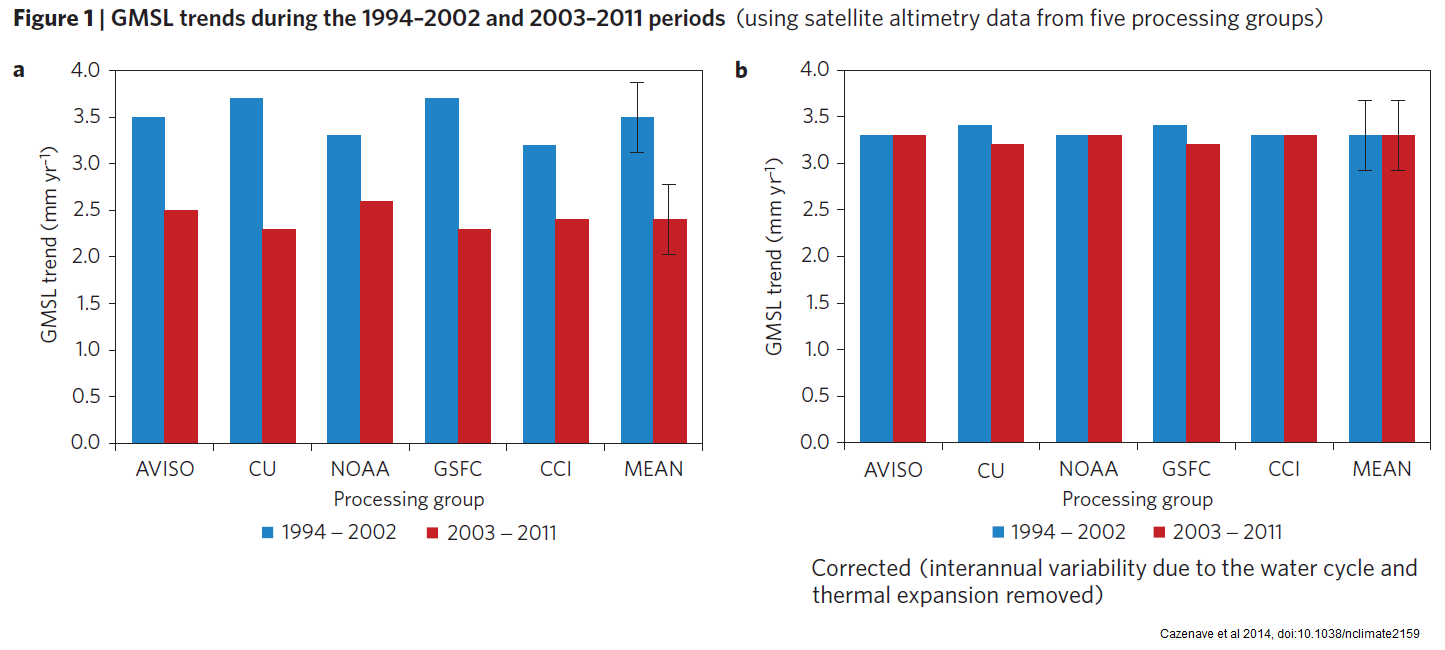
Also, satellite altimetry measurements have proven to be disturbingly malleable. The very same data can show acceleration, deceleration, or linearity, depending on how it is processed! Here's an example from a 2014 paper, which turned apparent deceleration into linearity, by changing ("correcting") the measurements.
sealevel.info/nclimate2159-f
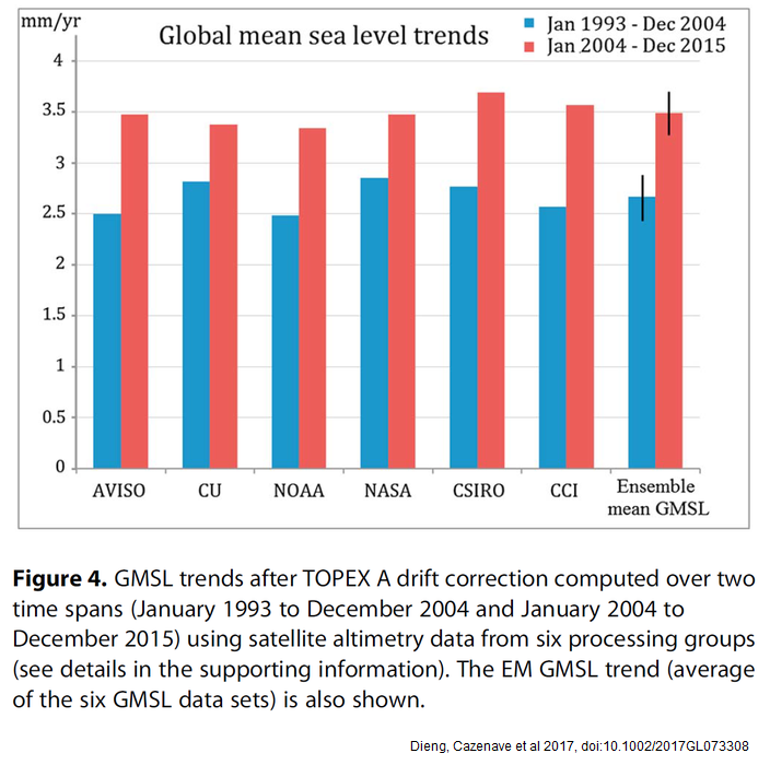
A subsequent paper then turned the linear trend into an acceleration, by a combination of additional corrections and a little bit of additional data:
sealevel.info/2017GL073308_f
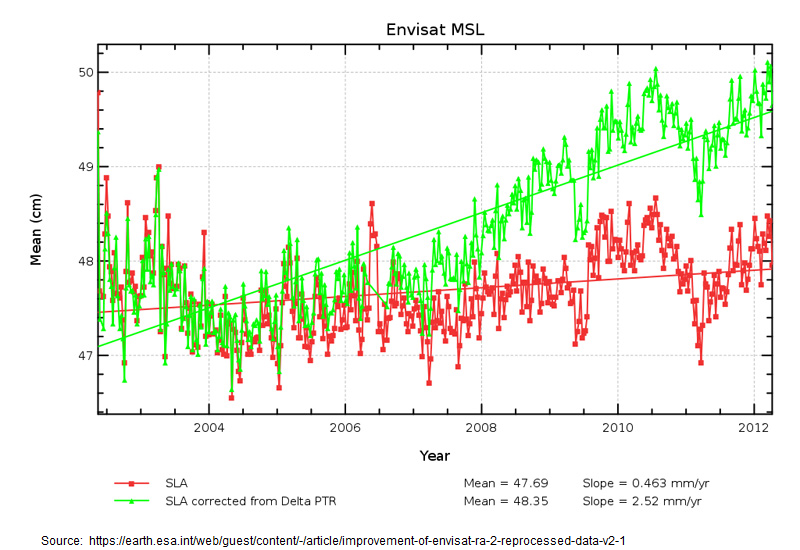
The 2012 Envisat revisions were especially striking:
sealevel.info/envisat_msl_co
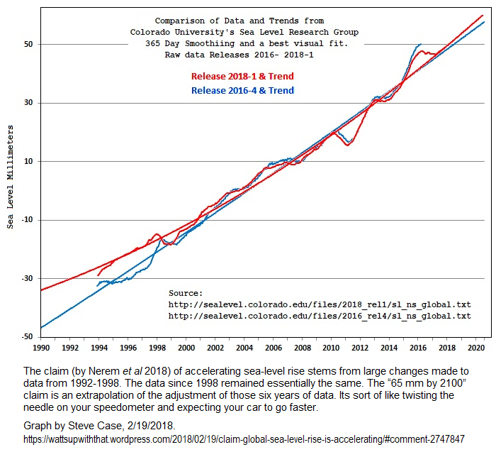
A widely-hyped 2018 paper by U. Colorado's Dr. Steve Nerem et al claimed to have discovered “acceleration” in the satellite altimetry measurement record of sea-level. They did it by reducing the rate of measured sea-level rise in 20 year-old Topex-Poseidon data, thereby making more recent measurements appear to have accelerated, by comparison. H/t Steve Case for this graph:
sealevel.info/CU-2016-2018-W
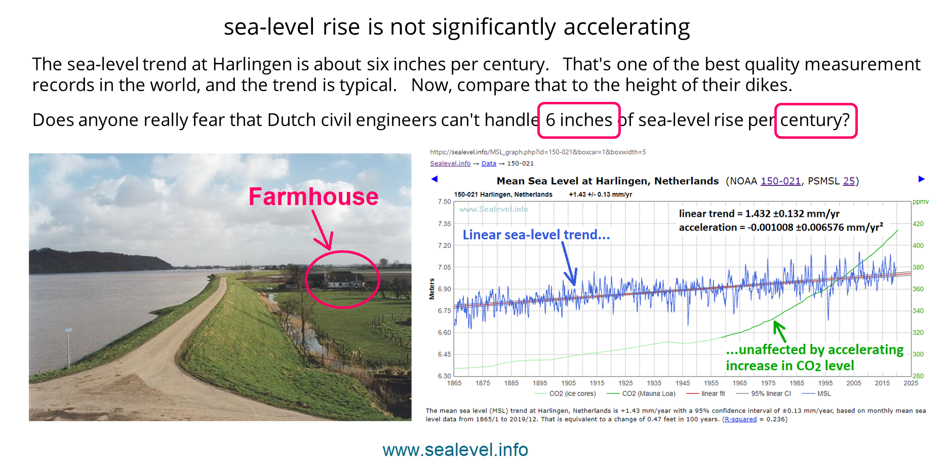
7/9. In contrast to the satellite measurements, most tide gauge (coastal) measurements continue to show little or no acceleration in sea-level trend in the last nine decades or more.
sealevel.info/MSL_graph.php?
sealevel.info/Dutch_dike_vs_
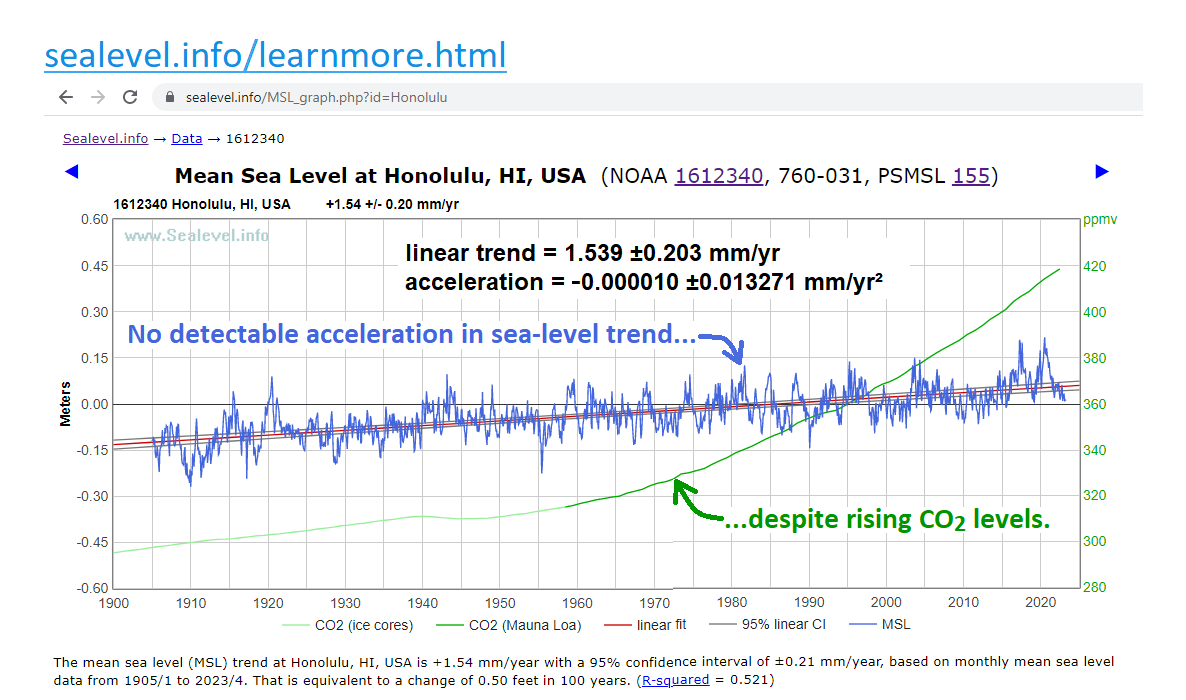
Honolulu is a nearly ideal sea-level measurement site:
sealevel.info/MSL_graph.php?
sealevel.info/1612340_Honolu
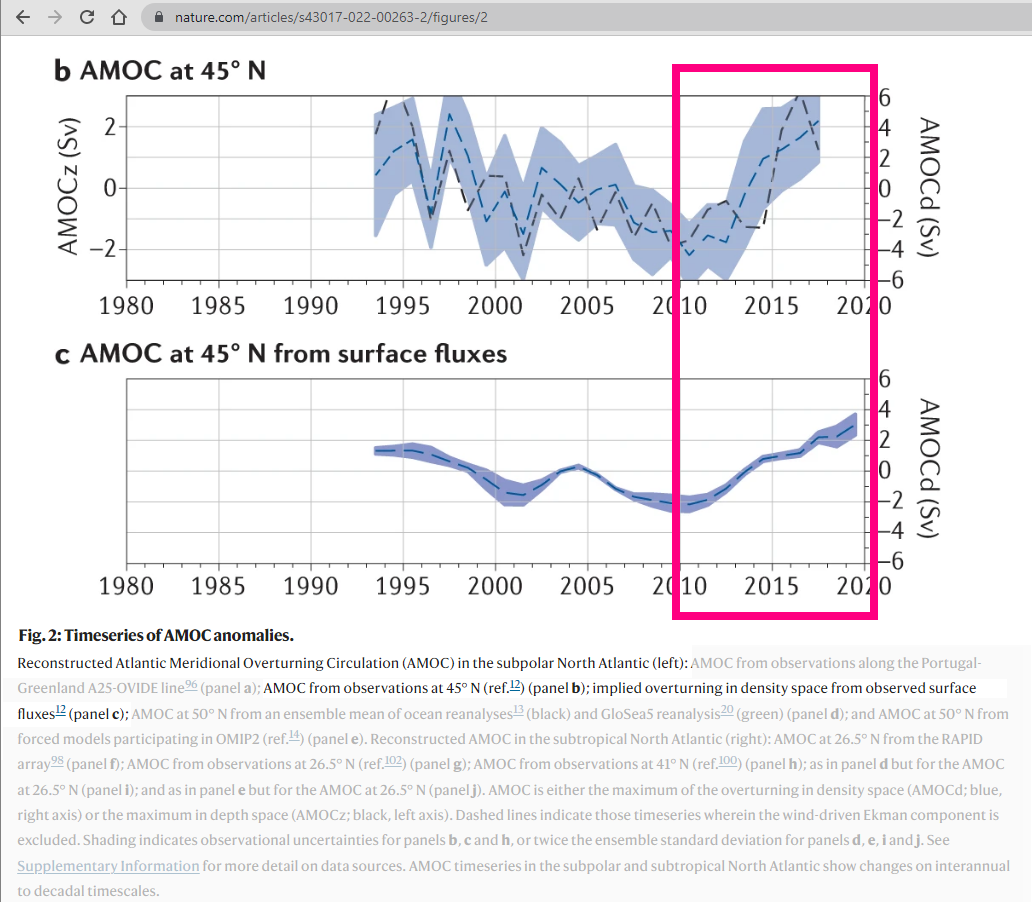
One exception to the general linearity of coastal sea-level trends is the southern half of the Atlantic coast of the United States, where the Gulf Stream skirts the coast. Thanks to a (presumably transient) acceleration of the Gulf Stream, sea-level rise there has accelerated strikingly over the last decade:
sealevel.info/MSL_graph.php?
sealevel.info/SL_Charleston_
This is the presumed cause:
sealevel.info/Jackson2022_FI
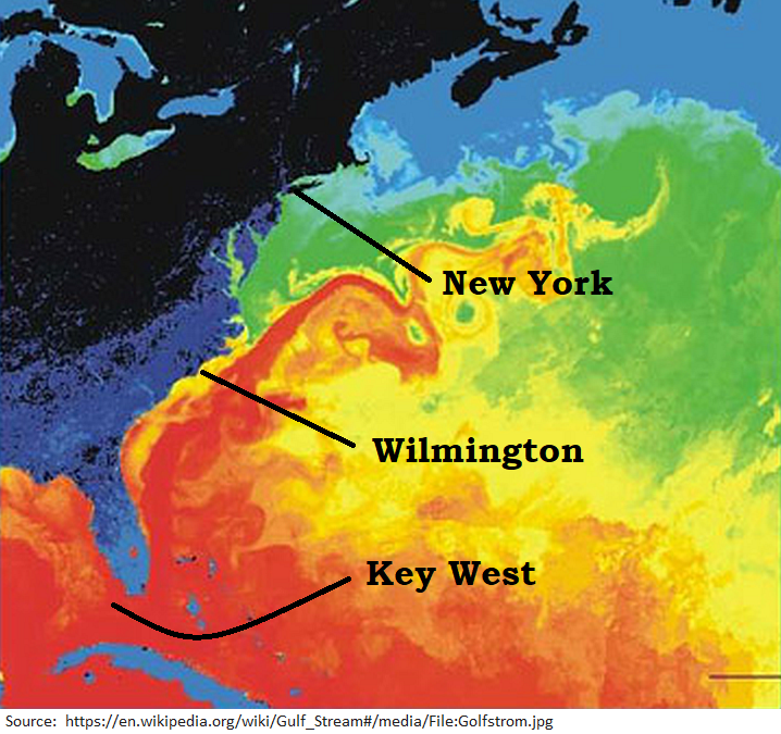
Here you can see how close to the coast the Gulf Stream is, in the SE United States:
sealevel.info/Gulf_Stream_wi
Here's nice video animation of a full year of AMOC:
youtube.com/watch?v=2RD3I6

8/9. CO2 emissions are highly beneficial, especially for agriculture and for natural ecosystems. The benefits of rising CO2 levels are large and well-measured. The supposed major harms are all merely speculative, and mostly implausible.
x.com/ncdave4life/st
Dave Burton@ncdave4life
Dave BurtonJun 01 22
View on Twitter
1/12》From all the hoopla about global warming, you'd think that warming was the main effect of CO2 emissions. It isn't. It is of very minor consequence compared to the major, proven, biological BENEFITS of higher CO2 levels in the atmosphere.
sealevel.info/learnmore.html

9/9. To understand a contentious & politicized topic like #ClimateChange, you need balanced information. You won't get it from @NASA Climate, but I'm here to help:
sealevel.info/learnmore.html
That resource list has:
● accurate introductory climatology information
● in-depth science from BOTH skeptics & alarmists
● links to balanced debates between experts on BOTH sides
● accurate information about impacts of CO2 & climate change, such as the effects on crop yields
● links to the best blogs on BOTH sides of the climate debate

Dave Burton
Dave Burton@ncdave4life
My preferred pronoun is "harmless data drudge." https://t.co/YTkK6vaHGs Tel: +1 919-481-0098.
Missing some tweets in this thread? Or failed to load images or videos? You can try to .